Map of Marinas and Boat Slips
Showing posts with label How To. Show all posts

How To Subscribe to SlipMaps.com Using Your Google Account

How to Subscribe

Subscribing to SlipMaps.com is simple:

  • Visit the SlipMaps.com website.
  • Use your Google account sign-in and start accessing the comprehensive database immediately.

How Much Does It Cost?

  • .03 Cents Per Day
  • $1 Per Month For Access to the Map Database 
  • Try it out for 7 days risk-free. 
  • Cancel at any time using your Google Subscriptions Account

💥 All-Access Map Bundle: 22 Maps for $9.95/month (FREE 7-day trial)

Syndicated Maps bundled subscriptions

Syndicated Maps has recently launched a value-packed bundled subscription that gives users access to all 22 of its niche maps for just $9.95 per month—a savings of over 50% compared to subscribing individually. This all-access plan was created in response to user demand for a more affordable way to explore multiple data layers across traffic enforcement, environmental hazards, wireless coverage, energy infrastructure, and public safety. Whether you're a researcher, commuter, traveler, or concerned homeowner, this bundle lets you seamlessly tap into detailed, location-based intelligence from across the entire network.

Each map serves a specific purpose—from helping drivers avoid speed traps to alerting families about nearby environmental hazards. The Syndicated Maps network has earned the trust of millions of users annually, including commuters, journalists, health professionals, and urban planners. 

Why Choose SlipMaps.com?

Extensive Coverage

Our meticulously curated map database covers thousands of marinas, anchorages, moorings, and yacht clubs around the globe. From hidden gems to popular spots, SlipMaps.com ensures you have access to the most comprehensive and up-to-date information.  

Real-Time Updates

Stay informed with real-time updates on marina facilities, anchorage conditions, mooring availability, and yacht club events. Our community-driven approach allows users to contribute and share valuable insights, keeping our database accurate and current.

Easy-to-Use Interface

Navigate with ease using our intuitive map interface. Find your next destination with just a few clicks, and access detailed information, including contact details, amenities, pricing, and user reviews.

Customizable Features

Tailor your experience with customizable features. Save your favorite spots, create personalized routes, and set alerts for specific locations. SlipMaps.com makes it easy to plan and manage your trips on the water.

Trusted by Mariners

Join a community of mariners who trust SlipMaps.com for their navigation needs. Our platform is designed by sailors, for sailors, ensuring that we provide the tools and information you need to sail confidently.

Best Free Apps to Avoid Protected and Risky Anchoring Zones

Safe Anchoring Starts with Smart Planning

Anchoring in the wrong spot can wreck more than your trip—it can damage your boat, harm sensitive marine environments, and result in hefty fines. Many of the most scenic and popular boating regions—like the Florida Keys, Aegean Sea, or San Francisco Bay—are also notorious for strong winds, crowded mooring fields, or poorly marked protected zones.

Today’s boating apps help you avoid these risks by showing real-time wind conditions, seabed quality, and legally restricted zones. This guide covers the best free and paid apps to help you find safe, legal, and wind-protected anchorages anywhere in the world.

Why Anchoring in the Right Spot Matters

Boaters often underestimate how fast things can go wrong:

📊 Boat Damage & Risk Statistics:

  • 33% of marine insurance claims involve vessel groundings—often due to anchoring in poor conditions.

  • 25% of anchored or moored boats suffer damage due to contact with other boats or drifting in wind-prone areas.

  • 15% of vessels that drag anchor do so because of sudden wind shifts and poor bottom holding.

  • NOAA estimates 80% of coral reef anchor damage in U.S. waters comes from recreational boaters unaware of protected zones.

Windy and Risk-Prone Anchoring Regions

Certain areas demand extra caution due to strong winds, unreliable seabeds, or strict environmental rules:

🌬️ Florida Keys & Biscayne Bay (USA)

  • Prone to squalls and sudden thunderstorms.

  • High enforcement of no-anchor zones over coral and seagrass beds.

🌬️ Aegean Sea – Greek Islands

  • Subject to powerful Meltemi winds (30–40+ knots) in summer.

  • Limited anchoring space, rocky seabeds, and rapid gusts.

🌬️ San Blas Islands (Panama)

  • Soft sand bottoms and shifting winds make anchoring unreliable.

  • Remote locations mean fewer fallback options.

🌬️ San Francisco Bay (USA)

  • Complex tidal flows and high winds make drag common.

  • Limited protected anchorages near the Golden Gate.

🌬️ Bay of Islands (New Zealand)

  • Frequent squalls, poor holding ground in some coves.

  • Proximity to marine sanctuaries requires awareness of boundaries.

Best Free and Paid Apps for Safe Anchoring

1. Windfinder (Free Web & App)

Platform:Free Web App, iOS, Android
Best for: Real-time wind forecasts and gust alerts

Windfinder is a favorite among sailors and kite surfers for good reason. It provides accurate wind speed, direction, and gust data—critical for anchoring decisions. Use it before setting anchor or to monitor conditions overnight.

Key Features:

  • 10-day wind and weather forecasts

  • Live gust maps and wind radar

  • Web-based with no signup required

  • Excellent for identifying exposed vs. sheltered anchorages

2. Navionics Boating

Platform: iOS, Android
Best for: Real-time nautical charts and no-anchor overlays

Navionics shows marine protected areas (MPAs), detailed seabed contours, and user-contributed anchoring notes. SonarChart helps you find the right depth and holding ground.

Key Features:

  • NOAA and international chart overlays

  • View MPAs and restricted zones

  • Offline navigation with community input

3. Savvy Navvy

Platform: iOS, Android, Desktop
Best for: Easy route planning with weather awareness

Savvy Navvy merges navigation with wind forecasts, tide info, and wave predictions. It’s designed to avoid both weather surprises and anchoring errors.

Key Features:

  • Shows legal anchoring areas

  • Wind and tide overlays

  • Auto-route generation with safety warnings

4. Aqua Map

Platform: iOS, Android
Best for: U.S. boaters needing regulatory clarity

Aqua Map displays anchoring restrictions and U.S. Army Corps updates. Its anchor alarm feature helps prevent dragging during windy nights.

Key Features:

  • Anchor position projection

  • Protected zone overlays

  • Waterway Guide and NOAA data integration

5. Navily

Platform: iOS, Android
Best for: User reviews of anchor spots across Europe

Navily is great for finding safe, legal anchorage with real-world reviews. Many users note bottom type, wind exposure, and legality.

Key Features:

  • Anchorage ratings by other boaters

  • Notes on holding ground and exposure

  • Color-coded protection status

6. MarineTraffic

Platform: iOS, Android, Desktop
Best for: Monitoring nearby vessel density and avoiding collisions

MarineTraffic is primarily an AIS tracker, but it helps anchor safely by showing where other boats are clustered—especially helpful during strong winds or busy weekends.

Key Features:

  • Live AIS tracking

  • Port and restricted zone alerts

  • Wind and current overlays

Bonus: NOAA Marine Sanctuary Maps (U.S. Only)

NOAA’s free sanctuary viewer shows no-anchor zones, coral protections, and habitat buffers. Use it with Navionics or Aqua Map for full U.S. coverage.

Final Thoughts

Safe anchoring means more than just dropping a hook. It requires knowing the wind, the bottom type, the law, and the crowd. Apps like Windfinder provide crucial real-time wind data, while tools like Navionics and Navily ensure you stay compliant and secure.

Pro Tip: Cross-check multiple apps when anchoring in remote or high-risk regions. If you're in a Meltemi-prone bay or anchoring near coral reefs, even a free web app like Windfinder can help prevent costly mistakes.

How To Avoid Reefs and Rocks: Boating Safety Tips

How to Avoid Reefs and Rocks When Boating

Navigating in new or unfamiliar waters can be both exciting and challenging. Whether you're sailing, kayaking, or operating a motorboat, hitting a reef or rocks can cause significant damage to your vessel and pose serious safety risks. Here are some essential tips to help you avoid these hazards:

1. Study Navigational Charts

Before setting out, review updated nautical charts of the area. Charts indicate the locations of reefs, rocks, and other underwater hazards. Pay attention to depth markings and any hazard symbols. The U.S. Coast Guard reported that 21% of boating accidents in 2022 involved collisions with fixed objects like reefs and rocks, underscoring the importance of chart review.

2. Use GPS and Depth Sounders

Modern GPS systems provide detailed mapping and real-time tracking. Combine this with depth sounders to monitor water depth and identify shallow areas that may hide reefs or rocks. According to BoatUS, vessels equipped with GPS and depth sounders are 35% less likely to encounter underwater hazards.

3. Stay Within Marked Channels

Follow established navigation channels whenever possible. These areas are typically marked with buoys, beacons, and markers that indicate safe passage. A 2024 NOAA study found that over 60% of groundings occurred outside of marked channels.

4. Pay Attention to Water Color

Clear, shallow waters over reefs often appear lighter in color. Darker water usually indicates deeper areas, while brown or green hues may signal the presence of rocks or sandbars. The Florida Fish and Wildlife Conservation Commission reports that 48% of reef strikes occurred in areas where water color changes were noticeable.

5. Monitor Weather Conditions

High winds, strong currents, and rough seas can make it harder to spot underwater hazards. Check weather forecasts and avoid navigating in adverse conditions whenever possible. The U.S. Coast Guard advises that nearly 25% of collisions with reefs and rocks occur during poor weather conditions.

6. Consult Local Knowledge

Speak with local marinas, harbor masters, or experienced boaters who are familiar with the area. They can provide valuable insights about hidden hazards and safe routes. According to a 2023 survey by the National Boating Safety Council, 73% of experienced boaters report consulting local knowledge as a key safety practice.

7. Use Lookouts

Assign a lookout to keep watch for reefs, rocks, and other obstacles. Having an extra set of eyes on deck can greatly reduce the risk of a collision. Studies indicate that vessels with designated lookouts experience 42% fewer collisions.

8. Reduce Speed in Unfamiliar Areas

Slowing down in uncharted or poorly mapped waters gives you more time to react to potential hazards. This can prevent accidental groundings or collisions. Data from the American Boating Association shows that over 50% of reef collisions occur at speeds exceeding 15 knots.

9. Understand the Impact of Tides on Navigation

Tides play a critical role in navigation, particularly in areas with reefs and rocks. The rise and fall of the tide can drastically alter water depth, exposing hidden hazards during low tide and concealing them during high tide. According to the National Oceanic and Atmospheric Administration (NOAA), approximately 31% of groundings occur during low tide when reefs and rocks that were previously submerged become navigational hazards.

  • Spring Tides vs. Neap Tides: During spring tides, water levels fluctuate more dramatically, increasing the likelihood of exposure to underwater hazards. Neap tides, on the other hand, result in smaller tidal changes and more consistent water depths.

  • Local Tide Charts: Reviewing tide charts before heading out can help boaters anticipate when water levels will be at their lowest or highest. Online resources and local marinas often provide real-time tide information.

  • Current Flow and Speed: Tidal currents can also impact navigation, pushing vessels off course or increasing drift, especially in narrow channels or near reefs. Understanding how the direction and speed of the current interact with tidal changes is crucial for safe navigation.

  • Storm Surges and Weather Events: Strong storms or heavy rainfall can cause storm surges, which may temporarily raise water levels, concealing hazards that are normally visible.

By accounting for these tidal factors and adjusting routes and speeds accordingly, boaters can significantly reduce the risk of accidental groundings and collisions.
Tides can significantly impact water depth, exposing reefs and rocks that were previously submerged. Check tide tables and plan your route accordingly. The National Oceanic and Atmospheric Administration (NOAA) states that 31% of groundings occur during low tide.

10. Stay Alert and Avoid Distractions

Stay focused on the water and your surroundings. Avoid distractions such as mobile phones, loud music, or excessive conversation while navigating in unfamiliar waters. The U.S. Coast Guard warns that distracted boating contributed to 19% of all reported collisions in 2022.

Conclusion

Avoiding reefs and rocks when navigating in unfamiliar waters requires a combination of preparation, vigilance, and situational awareness. By using navigation tools, consulting local knowledge, and maintaining a safe speed, you can significantly reduce the risk of accidents and enjoy a safer boating experience.

7-Day Senior Trip to Fiji: Surf, Party, and Explore

Planning a 7-day senior trip to Fiji? Whether you’re looking to catch world-class surf breaks, party on the beach, or explore the vibrant Fijian culture, Fiji is the ultimate destination for high school seniors seeking adventure and unforgettable memories. With stunning beaches, crystal-clear waters, and a tropical climate, your 7-day senior trip will be filled with exciting activities and relaxation. Here’s everything you need to know to make the most of your trip!

Best Time to Visit Fiji: Surfing and Partying Season

Fiji is a paradise for surfers and party-goers alike. To make the most of your trip, plan your visit during the dry season from April to October. This is when the waves are at their best, and the weather is sunny and perfect for outdoor activities.

  • Surfing: During the dry season, the waves are at their prime, with consistent swells reaching 8 to 10 feet. This is the ideal time to catch some of the world’s best waves at Cloudbreak and other popular surf spots.

  • Party Season: This is also the best time to enjoy vibrant nightlife and beach parties. Many resorts and beachfront bars host lively events throughout the season.

Surfing Hotspots in Fiji: Cloudbreak, Restaurants, and More

Fiji is home to some of the best surf breaks in the world, making it a must-visit for surfing enthusiasts. Here are some top surf spots you should check out:

Cloudbreak:

  • Cloudbreak is one of the most famous waves in the world, attracting surfers from across the globe. This reef break is known for its powerful barrels and challenging waves.

  • If you’re staying on Tavarua Island, you’ll have direct access to Cloudbreak. However, even if you’re staying on the mainland, boat trips to Cloudbreak are easily arranged and take around 30 to 60 minutes.

Restaurants:

  • Restaurants is another legendary surf spot, offering hollow, fast waves that are perfect for intermediate to advanced surfers.

Swimming Pools:

  • For those looking for a mellow ride, Swimming Pools is an excellent spot. Its long left-hand waves are perfect for both beginners and experienced surfers.

Boat Trips to Surf Spots:

  • Staying on the mainland means you’ll need to take boat trips to reach these famous surf breaks. Expect boat rides to take 30 to 60 minutes, making each trip an exciting adventure.

Snorkeling and Scuba Diving: Explore Fiji’s Underwater World

Fiji isn’t just a surf destination—it’s also a haven for underwater explorers. The coral reefs surrounding the islands are teeming with vibrant marine life, making it a prime location for snorkeling and scuba diving.

Snorkeling:

  • Discover the colorful coral reefs around the Mamanuca Islands and Coral Coast. You’ll encounter vibrant fish, turtles, and a diverse array of marine life. Many resorts offer guided snorkeling trips.

Scuba Diving:

  • For a more adventurous experience, dive into the Great Sea Reef or Bligh Water. These dive sites offer encounters with sharks, rays, and exotic fish in some of the clearest waters in the world.

Currency & Exchange Rate: How to Budget for Your Trip

Understanding the exchange rate between the US Dollar (USD) and Fijian Dollar (FJD) will help you budget your trip to Fiji more effectively.

  • 1 USD ≈ 2.26 FJD (as of May 2025)

  • 1 FJD ≈ 0.44 USD

The favorable exchange rate means you’ll get more value for your money, which can help cover additional activities, meals, and accommodation costs.

Currency Exchange Tips:

  • Avoid Airport Currency Exchange Counters: Airport exchanges typically charge higher fees and offer less favorable rates.

  • Use ATMs in Urban Areas: ATMs in Nadi and Suva tend to offer better exchange rates, but watch out for international fees.

  • Consider Travel-Friendly Credit Cards: Some credit cards offer no foreign transaction fees and competitive exchange rates.

Food Costs and Lodging in Fiji: What to Expect

Whether you’re staying in budget accommodations or splurging on a luxury resort, Fiji offers a wide range of dining and lodging options to suit every budget.

Food Costs:

  • Local Restaurants: Expect to pay about $10 - $20 USD per meal at casual eateries.

  • Resort Dining: Meals at higher-end resorts can cost between $25 - $50 USD per person.

  • Street Food: For a budget-friendly option, try samoa (fried dough) or roti (flatbread) for about $3 - $6 USD per meal.

Lodging Costs:

  • Budget Accommodation: Simple guesthouses or hostels range from $30 - $60 USD per night.

  • Mid-Range Accommodation: Expect to pay around $80 - $200 USD per night for hotels or resorts offering more amenities.

  • Luxury Resorts: High-end resorts charge between $250 - $600+ USD per night, with some offering all-inclusive packages.

Total Estimated Cost Per Person for a 7-Day Senior Trip to Fiji

Here’s a breakdown of the total estimated cost for a 7-day senior trip to Fiji, based on different travel styles:

Budget Traveler:

  • Accommodation: $210 - $420 (7 nights at $30 - $60 per night)

  • Food: $140 - $210 (3 meals per day at $10 - $20 per meal)

  • Transportation: $140 - $210 (boat trips, local transportation)

  • Total for 7 Days:$490 - $840 per person

Mid-Range Traveler:

  • Accommodation: $560 - $1,400 (7 nights at $80 - $200 per night)

  • Food: $210 - $350 (3 meals per day at $20 - $50 per meal)

  • Transportation: $210 - $350 (boat trips, taxis, etc.)

  • Total for 7 Days:$980 - $2,100 per person

Luxury Traveler:

  • Accommodation: $1,750 - $4,200 (7 nights at $250 - $600 per night)

  • Food: $350 - $700 (3 meals per day at $50+ per meal)

  • Transportation: $350 - $700 (boat charters, private transport)

  • Total for 7 Days:$2,450 - $5,600 per person

Safety Tips: What Not to Do in Fiji

While Fiji is generally safe for tourists, there are a few essential safety precautions you should follow:

Safety Guidelines:

  • Avoid Swimming in Unsafe Areas: Stick to designated swimming zones. Strong currents can be dangerous, especially near surf spots.

  • Respect Local Culture: Fijian culture is warm and welcoming, but it’s important to respect local customs. For example, always remove your shoes when entering homes or temples.

  • Be Careful Around Marine Life: Some marine creatures, like stingrays and sea urchins, can be dangerous. Always snorkel or dive with a guide.

  • Stay Hydrated and Protected: The tropical heat can be intense. Drink plenty of water and apply sunscreen to protect against sunburns.

Alcohol and Local Drink Kava: What to Expect

Alcohol in Fiji: Enjoying a Drink Responsibly

Fiji has a thriving tourism industry, and you’ll find a wide range of alcoholic beverages available throughout the islands. Whether you’re partying on the beach or enjoying a quiet evening at a resort, here’s what to know about alcohol in Fiji:

  • Fijian Beer: The local beer in Fiji is Fiji Bitter, a light lager that’s popular among both locals and visitors. Other common beers include Gold and Pure Lager.

  • Imported Alcohol: Most international brands, including Jack Daniel’s, Smirnoff, and various wines, are available at bars, restaurants, and resorts, though they can be more expensive than local drinks.

  • Cocktails: Enjoy tropical cocktails made with rum, vodka, or gin, often featuring local fruits like pineapple, coconut, and passionfruit. A Fijian cocktail commonly enjoyed is the "Fijian Daiquiri" or Pina Colada, both refreshing and perfect for the beach.

Drinking Etiquette:

  • Legal Drinking Age: The legal drinking age in Fiji is 18 years. Always carry an ID if you plan to drink.

  • Responsible Drinking: While many bars and resorts cater to the party crowd, it’s important to drink responsibly, especially when near the ocean, as alcohol can impair your judgment and increase the risk of accidents.

Kava: Fiji’s Traditional and Cultural Drink

Kava is a traditional Fijian drink made from the root of the kava plant (Piper methysticum) and has been consumed in Fiji for centuries. Known for its calming and relaxing effects, Kava plays an important role in Fijian culture and social life.

What Is Kava?

  • Preparation: Kava is prepared by grinding or pounding the root of the kava plant into a powder, which is then mixed with water to create a murky, earthy-tasting drink.

  • Effects: Unlike alcohol, Kava does not intoxicate you, but it has a calming, sedative effect. It’s known to relax the body and mind without impairing motor skills, making it a perfect drink for socializing in a peaceful setting.

Kava Ceremonies: A Cultural Experience

  • Kava Ceremonies: Drinking Kava is a communal ritual and is often served in traditional ceremonies. The ceremonies are a way for locals to welcome visitors, bond, and celebrate important occasions. During a ceremony, a designated “Kava master” prepares and serves the drink while participants sit in a circle.

  • How It’s Drunk: Kava is typically consumed in a small bowl or cup called a "bilo". After receiving the drink, you clap once, say "Bula!" (a traditional greeting), and drink it in one go. It’s common to say "Vinaka" (thank you) after drinking.

Where to Experience Kava:

  • Resorts and Cultural Experiences: Many resorts in Fiji offer guests the chance to participate in traditional Kava ceremonies, often as part of an authentic Fijian cultural experience.

  • Local Villages: If you venture into the rural villages, you may be invited to participate in a Kava ceremony with the locals. This is a great opportunity to immerse yourself in Fijian culture.

Kava's Effects:

  • Relaxing but Non-Intoxicating: While Kava has a calming effect, it does not impair coordination or mental clarity the way alcohol does. However, drinking too much in one sitting may make you feel tired or slightly woozy.

  • Health Benefits: Kava is believed to reduce anxiety, promote relaxation, and improve sleep quality. However, long-term use can have negative effects on your liver, so it’s essential to drink it in moderation.

Final Thoughts on Alcohol and Kava in Fiji

Whether you're unwinding with a cold Fiji Bitter after a surf session or enjoying the cultural experience of a Kava ceremony, alcohol and Kava are an integral part of life in Fiji. Make sure to enjoy both responsibly, especially if you're planning to party at local bars or take part in traditional Kava rituals. Fiji’s vibrant drink culture adds an extra layer of charm to your 7-day senior trip, offering a perfect blend of relaxation and fun.

Hemingway Marina - Cuba


Sailing to Cuba from Key West, Florida and Hemingway Marina near Havana is a nice option


Watch this episode of Sailing to Cuba on How Not To Sail

How Boat Marinas Prepare for Hurricanes? Steps to Minimize Damage

Hurricanes can bring catastrophic winds, heavy rainfall, and dangerous storm surges, making preparation essential for marinas. Protecting boats, and infrastructure, and preventing environmental hazards is critical for minimizing damage during these severe weather events. Here’s how marinas prepare for hurricanes and what steps can be taken to safeguard against potential damage.

1. Monitoring and Planning Early

How to Build a Pedal Drive Train Sailboat

Sailing is an age-old hobby that combines the serenity of being on the water with the challenge of harnessing wind power. Adding a pedal drive train to your sailboat can enhance its versatility and provide an alternative means of propulsion, especially when the wind is not in your favor. This guide will walk you through the process of building a pedal drive train for your sailboat, ensuring that you can enjoy the best of both worlds. 

How and When to Turn a Boat When Parking in a Boat Slip Under Sail

Navigating a sailboat into a slip under sail requires a different set of skills and techniques compared to using a motor. One effective method to control your speed is to use the mainsail to slow down. Here’s a detailed guide on how and when to turn your sailboat into a slip under sail.

Are Boat Slips Good Investments?

Investing in real estate is a well-trodden path towards financial security and wealth accumulation. But what about investing in a slightly different kind of real estate – boat slips? While not as commonly discussed as residential or commercial properties, boat slips present a unique investment opportunity that can yield lucrative returns for the savvy investor. However, like any investment, they come with their own set of considerations and risks.

How To Use Tide Charts for Boating Navigation

Navigating sailboats efficiently and safely requires a thorough understanding of tide charts. Tides, the periodic rise and fall of sea levels caused by the gravitational forces exerted by the moon and the sun, significantly affect marine navigation. Tide charts, which provide data on the predicted times and heights of tides, are indispensable tools for sailors. Here’s how to use tide charts for sailboat navigation.

Where Can You Legally Live on a Boat? Exploring Your Options

Living on a boat is a dream for many adventure seekers and those drawn to the allure of life on the water. The idea of waking up to the gentle rocking of waves and the freedom to explore new horizons is undeniably appealing. However, before embarking on this unique lifestyle, it's essential to understand the legalities and practicalities involved. Where can you legally live on a boat? Let's explore some options.

Does Starlink Work on a Boat in the Ocean?

In the realm of satellite internet services, Starlink has emerged as a revolutionary option, promising high-speed connectivity even in remote and challenging locations. With its constellation of low Earth orbit satellites, Starlink aims to provide internet access to areas where traditional infrastructure is limited or unavailable. But what about using Starlink on a boat in the middle of the ocean? Can it truly deliver reliable internet under such circumstances?

10 Essential Tips for Docking at a New Harbor

Docking at a new harbor can be an exciting yet nerve-wracking experience for boaters. Whether you're cruising along the coast or exploring new waters, proper preparation and knowledge are key to a smooth docking process. Here are essential tips to help you navigate and dock at a new harbor with confidence.

Mastering Boat Docking: Tips and Tricks for Smooth Maneuvers

Docking a boat can be a daunting task for both seasoned sailors and novices alike. The good news is that with practice and a few essential tips, you can navigate this challenge smoothly and confidently. Whether you're docking a small sailboat or a larger vessel, these tips will help you master the art of boat docking.

Safeguarding Your Boat in a Harbor During a Hurricane: Top Tips

Owning a boat can be a source of immense joy and relaxation, allowing you to escape the daily grind and explore open waters. However, when hurricane season arrives, that source of joy can turn into a cause for concern. Hurricanes pose a significant threat to boats, especially when they are moored in harbors. To ensure your vessel remains safe and secure during a hurricane, it's crucial to take proactive measures. In this article, we'll provide you with a comprehensive guide on how to protect your boat in a harbor during a hurricane, ensuring both your investment and peace of mind are preserved. 

Get live updates on Hurricane Helene

1. Stay Informed and Plan Ahead

How to Safely Clean Barnacles off a Boat in the Water


Keeping your boat's hull clean and free from barnacles is essential for optimal performance and fuel efficiency. While traditional methods involve dry-docking for barnacle removal, it's possible to tackle this task even when your boat is in the water. In this comprehensive guide, we'll walk you through step-by-step instructions on how to safely and effectively clean barnacles off your boat while it's still afloat.

The Challenge of In-Water Barnacle Cleaning:

15 Essential Precautions for Safely Towing Your Boat or Watercraft

When it comes to towing your cherished boat or watercraft, safety should be your top priority. Whether you're headed to a serene lake or an adventurous waterway, taking the right precautions can prevent accidents and ensure a hassle-free towing experience. In this article, we'll delve into the essential measures you should take to protect your valuable vessel during towing.

Saving Money on Boat Slips - 8 Tips

shared boat slip

If you're looking to save money on boat slips, here are some tips and strategies you can consider:

Shop Around: Take the time to research and compare prices at different marinas and boatyards in your area. Prices for boat slips can vary significantly, so getting quotes from multiple locations will help you find the best deal.

Off-Season Discounts: Many marinas offer discounted rates during the off-season when boat usage is lower. Consider taking advantage of these reduced prices by negotiating a long-term contract or storing your boat during the off-season.

Shared Slips: If you don't need your boat in the water all the time, you can explore sharing a boat slip with another boat owner. This arrangement allows you to split the costs of the slip, making it more affordable for both parties. Make sure to establish clear guidelines and expectations with the other owner to avoid any conflicts.

Dry Storage: Dry storage is often less expensive than wet slips. If your boat is suitable for dry storage, consider storing it on land instead of keeping it in the water. Dry storage facilities typically charge lower fees, and your boat will be protected from water-related issues such as algae growth and corrosion.

Boat Clubs and Memberships: Some boat clubs and organizations offer discounted rates on slips and storage for their members. Research local boat clubs and see if they have any cost-saving opportunities for slip rentals.

Negotiate Long-Term Contracts: If you're planning to keep your boat at a marina for an extended period, consider negotiating a long-term contract. Marinas may offer discounts or reduced rates for longer commitments, saving you money in the long run.

Do-It-Yourself Maintenance: Regular boat maintenance can help prevent costly repairs and extend the life of your boat. By taking care of your boat yourself and performing routine maintenance tasks, you can reduce the likelihood of unexpected expenses that could impact your budget.

Consider Alternative Storage Options: Look beyond traditional marinas and explore alternative storage options such as self-storage facilities, rack storage, or trailer storage. These options may offer more affordable rates compared to dedicated boat slips.

Remember, while it's essential to save money on boat slips, it's equally important to ensure that your boat is stored in a safe and secure location. Always consider factors like security, accessibility, and convenience when evaluating storage options to find the best balance between cost and quality.

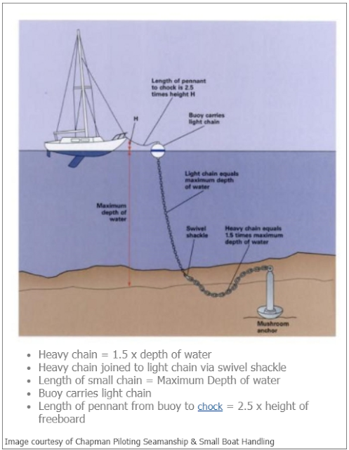
How to install a mooring anchor and what are the costs?

mooring installation

Installing a mooring anchor typically requires careful planning and the use of appropriate equipment. Here's a general guide on how to install a mooring anchor:

  1. Obtain necessary permits: Before installing a mooring anchor, make sure to check with local authorities or the relevant governing body to obtain any required permits or permissions.
  2. Determine the mooring location: Identify a suitable location for the mooring based on factors such as water depth, bottom conditions, and protection from waves and currents. Consider any regulations or guidelines that may apply to mooring placement in your area.
  3. Choose the right anchor and components: Select a mooring anchor suitable for the size of your vessel and the conditions in the area. Common types of mooring anchors include mushroom anchors, deadweight anchors, and helical screw anchors. Consult with a marine expert or an experienced boater to determine the appropriate anchor type and size for your specific needs.
  4. Gather the necessary equipment: You will need equipment such as a boat, a strong mooring line or chain, a buoy, shackles, and swivels. Additionally, you may require a GPS or chartplotter to accurately position the mooring.
  5. Prepare the anchor assembly: Attach a length of chain to the mooring anchor using a shackle, ensuring it is securely fastened. Connect the other end of the chain to a length of mooring line or rope using another shackle.
  6. Position the boat: Take your boat to the desired mooring location. Use a GPS or chartplotter to navigate and accurately position the boat over the intended installation spot.
  7. Lower the anchor: With the boat in the correct position, carefully lower the anchor and chain assembly into the water. Allow it to descend to the bottom.
  8. Set the anchor: Slowly back away from the anchor while allowing the chain to pay out. Use the boat's engine in reverse to apply tension to the chain, helping the anchor dig into the seabed.
  9. Secure the mooring line: Attach the free end of the mooring line or rope to a buoy using a suitable shackle. Ensure the buoy is of sufficient size to provide buoyancy to the mooring system.
  10. Test and adjust: Test the mooring by applying tension to ensure it is securely set. Monitor the mooring system periodically to ensure it remains properly positioned and undamaged.

It's important to note that mooring installation can vary depending on the specific circumstances and regulations in your area. Therefore, it's recommended to consult with local authorities or seek advice from professionals with expertise in mooring installation in your region.

How do calculate the size of a mooring for boats?

Calculating the size of a mooring for boats involves considering several factors to ensure it can adequately support and secure the vessel. Here are the key considerations:

  1. Boat size and weight: Determine the size and weight of your boat, including any additional equipment or supplies that may affect its overall weight. This information is crucial for selecting an anchor and chain/rope of appropriate strength and size.
  2. Water conditions: Assess the prevailing water conditions in the mooring area, including wave action, current strength, and tidal changes. These factors will influence the type and size of the mooring anchor required for stability and holding power.
  3. Bottom conditions: Evaluate the composition and conditions of the seabed in the mooring area. Different bottom types, such as sand, mud, or rocky surfaces, may require specific anchor types or additional considerations.
  4. Windage and exposure: Consider the windage of your boat, which refers to its susceptibility to wind forces. Boats with larger superstructures or sailboats generally have higher windage. Additionally, assess the exposure of the mooring area to prevailing winds to determine the necessary holding power of the mooring.
  5. Safety factor: It is recommended to apply a safety factor to the calculations to ensure the mooring can handle unexpected loads and account for any potential variations or uncertainties. A safety factor of 2 to 3 times the calculated load is typically considered.
  6. Consultation and guidelines: Seek guidance from marine experts, experienced boaters, or local authorities who may have specific guidelines or regulations regarding mooring size and requirements in your area.

It's important to note that calculating the size of a mooring can be complex, and professional advice is highly recommended to ensure the safety and suitability of the mooring for your specific boat and location. Consulting with marine engineers, naval architects, or experienced marine contractors can help you make informed decisions and ensure proper sizing and installation of the mooring system.

What is the cost to install a mooring?

The cost to install a mooring can vary significantly depending on various factors, including the location, size of the vessel, water depth, and specific requirements. Here are some of the common cost factors to consider:

  • Equipment and materials: This includes the cost of the mooring anchor, chain or line, shackles, swivels, buoys, and any additional components required for the installation. The cost can vary depending on the type and size of the anchor, quality of materials, and the length and strength of the chain or line.
  • Permit fees: Some locations may require permits or approvals for installing a mooring. These permits often involve associated fees, which can vary depending on the jurisdiction.
  • Professional services: If you choose to hire professionals to install the mooring, there may be additional costs. This can include fees for marine contractors, divers, or surveyors who assess the mooring location and handle the installation process.
  • Maintenance and inspection: Mooring systems require periodic maintenance and inspection to ensure their safety and functionality. This may involve costs for hiring professionals or purchasing equipment for inspections and maintenance tasks.
  • Miscellaneous costs: Other expenses may include transportation of equipment, fuel costs, and any specialized tools or equipment needed for the installation.

Due to the variability of these factors, it's challenging to provide an exact cost without specific details about your location and requirements. It is recommended to consult with local marine contractors, boatyards, or mooring specialists who can provide accurate cost estimates based on your specific situation and local market conditions.

Most Visited Maps